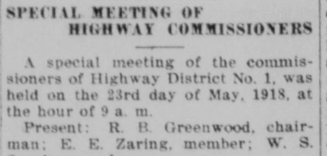
The road out of Bannock valley to Michaud ran along an old railroad grade, and in the spring of 1918 the government said it would not stay there. At 9 o’clock on the morning of May 23, the three commissioners of Highway District No. 1 met in special session to hear what R. B. Greenwood, their chairman, had learned from H. H. Miller, superintendent of the Fort Hall reservation. New roads were to keep to section lines or allotment lines wherever they could, the Indian department had asked. The old road “does not follow allotment lines, and will eventually be closed.”
The board accepted the report and changed course at that same meeting. The American Falls Press printed the minutes the next day.
Farmers on the creek before the surveyors
North of Pauline, Bannock Creek flows on into the Fort Hall Reservation. Tribal families were raising crops along it well before anyone drew allotment lines. W. T. Oliver, writing his recollections for the Press in February 1915, put the first plowing there in 1881, when Mosho, Pocatello Tom, China Eye and two other men took up places on the creek a little above where the railroad crosses it. They put in a few potatoes and a few acres of wheat.
Allotment came to the reservation a generation later. A Boise paper explained the system in 1909, in a piece the Press reprinted: every member of a family, not just its head, would receive land of his or her own, kept “held in trust for a number of years” so that no buyer could pick the claims up cheaply. In May 1911 the Press carried an item from the Pocatello Tribune, much of it too worn to read in the scan, reporting that the allotting party had been at work nearly the whole winter. Iron posts were to mark the corners of land owned by tribal members, it seems because of quarrels over boundaries with white homesteaders.
A new road before the land was divided
Arbon belonged to Oneida County until 1913, then to the new Power County, with its seat at American Falls. The valley’s way to Michaud, the railroad stop between American Falls and Pocatello, crossed the reservation, and the Power County commissioners could see that allotment might shut it. The government was “now allotting the lands in Bannock valley on the reservation,” their minutes said in the Press of October 28, 1915, and once that was done no permission for a highway would be granted. Without one, the people of Arbon or Bannock valley “would have no means of egress or ingress.”
So they built ahead of the surveyors. Highway District No. 1 put in the southern 5.2 miles across the reservation under a contract dated June 14, 1915, and that October the county ordered its bill of $4,554.08 paid. The valley’s column in the Press of December 2, 1915, said the farmers had abandoned the old track over the reservation to Michaud for the new county road and were “very proud of” it.
Pauline men on leased ground
An allotment could also be rented to a farmer from outside. “W. E. Dawson is busy plowing his leased land near Birch creek on the Indian reserve,” the Arbon column noted in June 1916. Dawson, born at Weston, Idaho, in 1872, had taken up a homestead near Pauline in 1908 and served as the Meadow Ward’s first clerk. The Press gave his harvest in the fall of 1917:
W. E. Dawson, who owns and farms a quarter section of fine land, one mile southwest of Pauline, this year harvested an average of 12 bushels of Turkey Red wheat from 130 acres on this ranch, and from 150 acres which he is farming on the Fort Hall reservation he harvested from 10 to 14½ bushels per acre of Turkey Red.
A profile that November made the reservation tract 130 acres, averaging 14½ bushels. Neither report names the allottee whose land he worked.
Another man from the valley went to live on the reservation. In May 1917 the Idaho Republican of Blackfoot, writing about farms at the Blackfoot and Fort Hall end, far north of Bannock Creek, reported that “Wallace Jenks is a white man who moved recently from the Bannock valley country to the reservation and is leasing 80 acres.” He was probably the W. W. Jenks who had homesteaded near Pauline. The same column told of tribal farmers working their own allotments alongside the white lessees.
Neither farm came through the next decade whole. Both the Dawson and the Jenks places were caught in the foreclosures of 1920–1925.
Turning north to the survey
By 1918 the allotments were deciding where a road could run. Superintendent Miller’s office recommended that any road from Bannock Creek to Michaud be laid on the survey of the Idaho Pacific highway, north of the railroad track, and that the connection from the Bannock Valley road reach that survey by the shortest practicable route. Greenwood, E. E. Zaring and W. S. Sparks accepted the report and voted to turn the road they were then building north along the east side of section 20 to meet it. With no other business, they adjourned.
The allottees
More than fifty trust patents in the federal land records cover ground in the two reservation townships north and west of Pauline. Nearly all are dated May 23, 1916, and most are for 180 acres. Among the names the land office set down are Pocatello, Dover, Hardy, Yupe, Ondabaga and Mosho, a David Mosho among them.
On June 3, 1921, the Press reported that a “Bannock Indian of note” was to be buried that day at his ranch home on the reservation near Rattlesnake Creek. The worn scan gives his name as Dave Mosho or something near it. The paper spoke well of him and said several local people meant to go to the funeral. He may have been the David Mosho of the 1916 patent, and perhaps the Mosho of Oliver’s memory, though no record read for this story says so. The name surfaced again in 1988, when a range fire on the reservation northwest of Pauline went into the reports as the Mosho fire.
Land of the dead for sale
The Indian Service also sold off allotments whose owners had died. In January 1922 the Fort Hall superintendent asked for bids, due March 1, “for the sale of deceased Indian land”: irrigable tracts of 20 and 80 acres and grazing tracts of 160 acres in Power, Bannock and Bingham counties. Like notices followed in 1923 and 1924. None of them lists the parcels, so it cannot be said whether any Bannock Creek ground was sold, or to whom.
The papers told all of this from the settlers’ side. They did not ask the Bannock Creek families what they made of allotment, the leases or the new road. The Tribes’ own history says the reservation was brought down to its present size “through subsequent legislation and the allotment process.” A speaker quoted in the Sho-Ban News in November 2024 put today’s reservation at about 546,000 acres, 97 percent of it held in trust for the Tribes and for individual allottees.
The creek’s longer story runs through Pauline and West Fork, United States v. Daniels and the first state highway. The road the commissioners turned north in 1918 still had to bend to lines drawn for the people who were there first.
The original article
American Falls Press, May 24, 1918, page 2. Transcribed from the page scan.
SPECIAL MEETING OF HIGHWAY COMMISSIONERS
A special meeting of the commissioners of Highway District No. 1, was held on the 23rd day of May, 1918, at the hour of 9 a. m.
Present: R. B. Greenwood, chairman; E. E. Zaring, member; W. S. Sparks, member.
Chairman Greenwood reported as to the meeting with Superintendent H. H. Miller of the Fort Hall Indian reservation, to the effect that the Indian department had requested that all new roads or highways be constructed, as far as practicable, on section lines or allotment lines, and that the old road between Bannock creek and Michaud as now constructed on the old railroad right of way grade, does not follow allotment lines, and will eventually be closed, and that the department would recommend that if the highway district desires to construct a road from Bannock creek to Michaud, that the road be built on the survey of the Idaho Pacific highway, north of the railroad track, and that the district, in making connection between the Bannock Valley road and the Idaho Pacific highway survey, reach the survey above mentioned in as short a distance as practicable.
The above report was accepted, and it was voted that the road now being constructed between the Bannock valley road and Michaud, turn north along the east side of section 20, township 6 south, range 33 east, Boise meridian to reach the survey of the Idaho Pacific highway.
No other business coming before the meeting, the board adjourned.
R. B. GREENWOOD, Chairman.
ATTEST R. FOSTER LAMM, Secretary.
Sources
- American Falls Press, February 6, 1909, page 1
- American Falls Press, May 6, 1911, page 1
- American Falls Press, February 4, 1915, page 1
- American Falls Press, October 28, 1915, page 6
- American Falls Press, December 2, 1915, page 3
- American Falls Press, June 8, 1916, page 8
- Idaho Republican, May 28, 1917, page 2
- American Falls Press, October 30, 1917, page 3
- American Falls Press, November 23, 1917, page 3
- American Falls Press, May 24, 1918, page 2
- American Falls Press, June 3, 1921, page 1
- American Falls Press, January 27, 1922, page 2
- American Falls Press, October 4, 1923, page 7
- American Falls Press, February 28, 1924, page 7
- General Land Office, trust patent to David Mosho, May 23, 1916 (IDIDAA 005019)
- Shoshone-Bannock Tribes, About
- Sho-Ban News, November 21, 2024